Bach Ma National Park 2026: Waterfalls, Summit and French Villas
Book an experience
Top-rated experiences in Lang Co & Bach Ma
The highest-rated tours and activities in Lang Co & Bach Ma. Book today, cancel free if plans change.
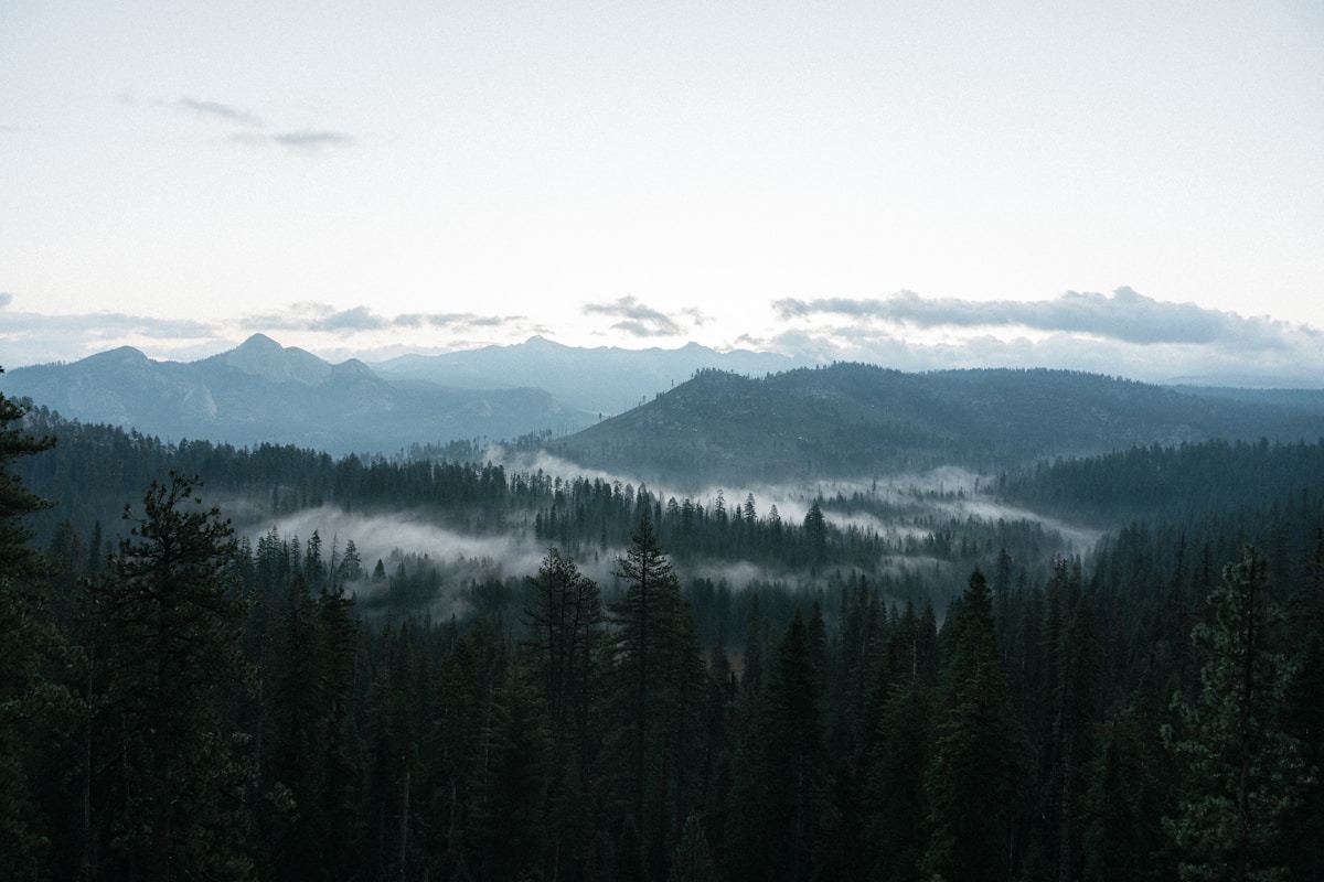
Bach Ma National Park covers the mountain directly above Lang Co and stretches into the forested highlands between Hue and Da Nang. The park reaches 1,450m at the summit, has several significant waterfalls, and contains the ruins of a French colonial hill station built in the 1930s.
Overview
The French administration established a hill station at Bach Ma from 1930 to serve Hue’s colonial population — 139 villas were built in the cool mountain air. The station was abandoned and destroyed during the American War. The ruins of many villas remain in the park, now overgrown and progressively returning to forest.
The park covers 22,030 hectares of subtropical mountain forest. It sits at the intersection of northern and southern Vietnam’s climatic zones — the Hai Van Pass immediately below is the weather boundary. This creates exceptional biodiversity: over 1,900 plant species and 300 bird species have been recorded.
Getting to the park
From Lang Co: The park road entrance is 16km from the Lang Co town centre. The road climbs from sea level to the summit in 19km. Motorbike or car required. Park entry: ₫60,000 ($2.40).
From Hue: 45km via Highway 1 and the park access road. Organised day trips or self-drive motorbike.
From Da Nang: 50km via the Da Nang–Hue road and the park access road.
Summit Road and Viewpoints
The main park road climbs 19km to the summit at 1,450m. Several viewpoints along the road provide views of the coast, the Hai Van Pass, and on clear days, the Truong Son mountain range extending into Laos.
Cloud conditions: The summit is frequently in cloud, particularly in the morning. The clearest views are in March–April. In the wet season (October–December) cloud cover is nearly permanent.
French Villa Ruins: Scattered throughout the summit area and along the road. The moss-covered stone walls, collapsed chimneys, and overgrown foundations of the colonial holiday homes are the park’s atmospheric signature. The most accessible ruins are near the summit parking area.
Waterfalls
Do Quyen Waterfall (Rhododendron Falls): The largest and most visited fall in the park — 300m high. Reached by a 6km trail from the summit area. The trail descends steeply, meaning the return is uphill. 3–4 hours round trip.
Five Lake Cascade (Suoi Mo): A series of five connected pools and falls in the forest, each accessible by trail and steps. Swimming is possible in the lower pools (clear, cool water). 8km trail from near the park gate. 3–4 hours.
Tri Sao Waterfall: Shorter and easier trail (2km) from the summit area. A good option for those without the energy for the longer falls.
Bird Watching
Bach Ma is one of Vietnam’s premier birdwatching sites — 300+ species including Edwards’s pheasant (critically endangered, endemic to Vietnam), silver pheasant, and a wide range of sunbirds and flycatchers. Organised birdwatching guides available through the park office.
Practical notes
Rain: Bach Ma is one of the wettest places in Vietnam — the summit receives up to 8,000mm of rain annually. Waterproof gear is essential even in the dry season. The trails are frequently wet.
Motorbike: The 19km summit climb is manageable on an automatic scooter in dry conditions. In wet conditions, the road is slippery — take caution.
Accommodation in the park: Basic guesthouses near the summit for those wanting a sunrise stay. Book through the park office.
More in Lang Co
- Lang Co Beach 2026: Lagoon Peninsula Swimming and the Hai Van Coast
- Best Hostels in Lang Co 2026: Budget Stays in a Small Coastal Hamlet
- Getting to Lang Co 2026: From Hue, Da Nang and Hoi An
- Things to Do in Lang Co 2026: Pass Road, Beach and Bach Ma
- Where to Stay in Lang Co 2026: Beach Hotels and Guesthouses
Frequently Asked Questions
- How do I get to Bach Ma National Park from Lang Co?
- The park entrance is 16km from Lang Co town. The road climbs from sea level to the summit in 19km. Motorbike or car required. Park entry costs 60,000 VND ($2.40). From Hue it is 45km; from Da Nang 50km.
- What are the best waterfalls in Bach Ma National Park?
- Do Quyen Waterfall (Rhododendron Falls) is the largest at 300m, reached by a 6km trail (3-4 hours round trip). Five Lake Cascade has connected pools for swimming in cool, clear water (8km trail, 3-4 hours). Tri Sao Waterfall is a shorter 2km trail.
- Are there French colonial ruins in Bach Ma National Park?
- Yes. The French built 139 villas as a hill station from 1930. The ruins — moss-covered stone walls, collapsed chimneys, overgrown foundations — are scattered through the summit area. They are the park's atmospheric signature.
- Is Bach Ma good for bird watching?
- Excellent. Bach Ma has 300+ recorded bird species including the critically endangered Edwards's pheasant (endemic to Vietnam), silver pheasant, and diverse sunbirds and flycatchers. Guides are available through the park office.
Ready to explore?
Browse hundreds of tours and activities. Book securely with free cancellation on most options.
Browse on GetYourGuide →We may earn a small commission — at no extra cost to you.